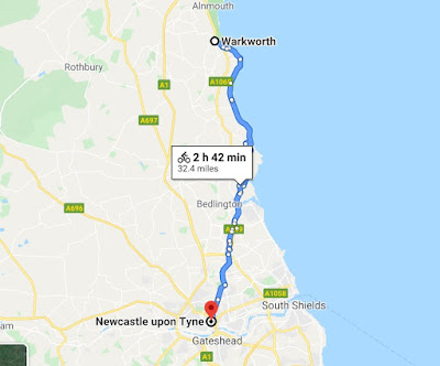
Maps from Google Maps and all images from Street View.
94.1 km/58.6 mi. - 52.1 km/32.4 mi. = 42 km/26.2 mi (banked)
1. Welfield Road, Warkworth
2. Amble Bank bicycle path
3. Amble Harbour
4. Beach huts at Little Shore, Amble Harbour Village
5. Links Road, Amble
6. Entry to the bicycle path at Lower Hauxley Beach
7. North Sea coast at Morpeth
8. Dunbar Burn
9. Pele Tower, Cresswell
10. The A189
11. Bicycle path at Newington Road, Newcastle Upon Tyne
12. Lime Road, Newcastle Upon Tyne
13. Hadrian's Wall Path, with the Gateshead Millenium Bridge
14. Quayside, with the Sage Gateshead and the Tyne Bridge
15. My virtual stay, the Premier Inn, Quayside

Anyone returning to look for teaching resources should look at the archived material from 2017 and earlier. On April 2, 2020 I re-purposed this site to reflect my current interests. At this time I can travel only in the virtual universe because of the Covid-19 pandemic. From Sunday, March 22 I've logged exercise bike and real bike kilometers, applied distances in Google Maps, and am taking a virtual ride to the homes of relatives here, in the UK and in Europe.
Blog Archive
-
▼
2020
(81)
-
▼
June
(12)
- The (Virtual) Peripatetic Pensioner - Stage 35 of ...
- The (virtual) Peripatetic Pensioner - Stage 34 of ...
- The (Virtual) Peripatetic Pensioner - Stage 33 of ...
- The (Virtual) Peripatetic Pensioner - Stage 32 of ...
- The (Virtual) Peripatetic Pensioner - Stage 31 of ...
- The (Virtual) Peirpatetic Pensioner - Stage 30 of ...
- The (Virtual) Peripatetic Pensiioner - Stage 29 of...
- The (Virtual) Peripatetic Pensioner - Stage 28 of ...
- The (Virtual) Peripatetic Pensioner - Stage 27 of ...
- The (Virtual) Peripatetic Pensioner - Stage 26 of ...
- The (Virtual) Peripatetic Pensioner - Stage 25 of ...
- The (Virtual) Peripatetic Pensioner - Stage 24 of ...
-
▼
June
(12)


